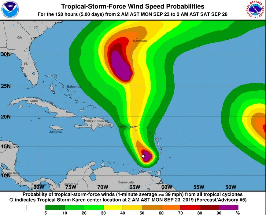
23 September 2019 Fire Chief/National Disaster Coordinator Clive Richardson is calling on the populace to closely monitor the progress of Tropical Storm Karen, the 11th storm of the season that formed over the weekend in the southern Caribbean.
The Meteorological Department of Sint Maarten (MDS) in a Special Weather Bulletin on Sunday afternoon, stated that Tropical Storm Karen was over 300 miles south of the country.
Karen is forecast to pass approximately 175 miles to the west-southwest of Sint Maarten on Tuesday afternoon.
MDS will continue to monitor closely the progress of the storm and will keep the public updated accordingly.
The Emergency Operations Center (EOC) is prepared and stands ready to convene should Tropical Storm Karen pose a direct threat to the country.
The community and new residents are urged to learn more about hurricane hazards and how to prepare for a storm/hurricane strike by visiting the Government website: www.sintmaartengov.org/hurricane where you will be able to download your “Hurricane Season Readiness Guide’ and “Hurricane Tracking Chart.”
During the season, weather authorities issue watches and warnings with respect to a tropical storm or hurricane. Residents should be familiar with these terms.
A Tropical Storm Watch is issued when a tropical cyclone containing winds of 34 to 63 knots (kt) (39 to 73 miles per hour (mph) or higher and poses a possible threat, generally within 48 hours. These winds may be accompanied by storm surge, and/or coastal flooding. The watch does not mean that tropical storm conditions will occur. It only means that these conditions are possible.
A Tropical Storm Warning is issued when sustained winds of 34 to 63 kt (39 to 73 mph) or higher associated with a tropical cyclone are expected in 36 hours or less. These winds may be accompanied by storm surge, and/or coastal flooding.
A Hurricane Watch is issued when a tropical cyclone containing winds of 64 kt (74 mph) or higher poses a possible threat, generally within 48 hours. These winds may be accompanied by storm surge, and/or coastal flooding. The watch does not mean that hurricane conditions will occur. It only means that these conditions are possible.
A Hurricane Warning is issued when sustained winds of 64 kt (74 mph) or higher associated with a tropical cyclone are expected in 36 hours or less. These winds may be accompanied by storm surge, and/or coastal flooding. A hurricane warning can remain in effect when dangerously high water or a combination of dangerously high water and exceptionally high waves continue, even though winds may be less than hurricane force.
The remaining storm names for the 2019 Atlantic hurricane season are: Lorenzo, Melissa, Nestor, Olga, Pablo, Rebekah, Sebastien, Tanya, Van and Wendy.
Listen to the Government Radio station – 107.9FM – for official information and news before, during and after a hurricane.
For official weather-related information, check out the website of the Meteorological Department of St. Maarten (MDS): www.meteosxm.com
The Atlantic hurricane season officially ends on November 30.

