
11:00am Hurricane Irma Update
…POTENTIALLY CATASTROPHIC CATEGORY 5 HURRICANE IRMA HEADING TO THE LEEWARD ISLANDS…
AT 11:00 AM…THE EYE OF HURRICANE IRMA WAS LOCATED NEAR LATITUDE 16.8 NORTH…LONGITUDE 58.4 WEST OR ABOUT 320 MILES EAST-SOUTHEAST OF ST. MAARTEN.
IRMA IS MOVING TOWARD THE WEST NEAR 14 MPH (22 KM/H). THIS MOTION IS EXPECTED TO CONTINUE TODAY, FOLLOWED BY A TURN TOWARD THE WEST-NORTHWESTWARD TONIGHT.
REPORTS FROM A HURRICANE HUNTER AIRCRAFT INDICATE THAT THE MAXIMUM SUSTAINNED WINDS ARE MEAR 180 MPH…285 KM/H…WITH HIGHER GUSTS.
IRMA IS AN EXTREMELY DANGEROUS CATEGORY 5 HURRICANE.
SOME FLUCTIONS IN INTENSITY ARE LIKELY DURING THE NEXT DAY OR TWO, BUT IRMA IS FORECAST TO REMAIN A POWERFUL CATEGORY 4 OR 5 HURRICANE DURING THE NEXT COUPLE OF DAYS.
HURRICANE FORCE WINDS EXTEND OUTWARD UP TO 60 MILES (95KM) FROM THE CENTER AND TROPICAL STORM FORCE WINDS EXTEND UP TO 160 MILES (260KM) FROM THE CENTER.

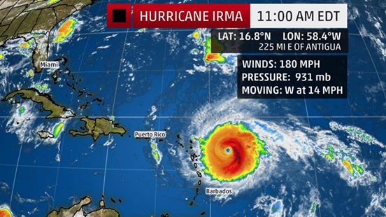


THE ESTIMATED MINIMUM CENTRAL PRESSURE IS 931 MB…27.50 INCHES.
ON THE FORECAST TRACK, THE CENTER OF IRMA WILL MOVE VERY CLOSE TO ST. MAARTEN SOMETIME ON WEDNESDAY MORNING. HOWEVER CONDITIONS WILL DETERIORATE THIS EVENING.
HAZARDS AFFECTING LAND AND SEA
WIND:
Hurricane conditions are expected in St. Maarten by later TONIGHT into tomorrow, however Tropical storm force winds are expected earlier this evening.
RAINFALL: Irma is expected to produce total rainfall accumulations of 8-12 inches with isolated maximum amounts of 18 inches across the Leeward Islands.
STORM SURGE: The combination of a dangerous storm surge and large breaking waves will raise water levels by as much as 7 to 11 feet above normal tide levels along the coasts of St Maarten. Near the coast, the surge will be accompanied by large and destructive waves.
SEAS: Swells generated by Irma will affect the local area for the next several days. These swells are likely to cause life threatening surf and rip current conditions especially on the northern and eastern shores. Mariners are advised to stay in port in order to safeguard life and property.
ALL RESIDENTS/VISITORS ARE STRONGLY ADVISED THAT ALL PREPARATIONS FOR THE ARRIVAL OF THIS EXTREMELY DANGEROUS SYSTEM SHOULD BE RUSHED TO COMPLETION AND CONTINUE MONITORING THE PROGRESS OF THE HURRICANE.
THE METEOROLOGICAL DEPARTMENT WILL CONTINUE TO MONITOR HURRICANE IRMA AND ISSUE SPECIAL WEATHER BULLETINS.