
Their last update, just like the St Maarten government is four ours ago. Anyone with any newer information please email judithroumou@gmail.com
Here are all of Laser’s Updates, I am unable to get PJD2 Live.
SWT_fbcover
NAB award winning radio broadcasting team known for providing up-to-date worldwide live weather information for St. Maarten and neighboring islands.
BULLETIN
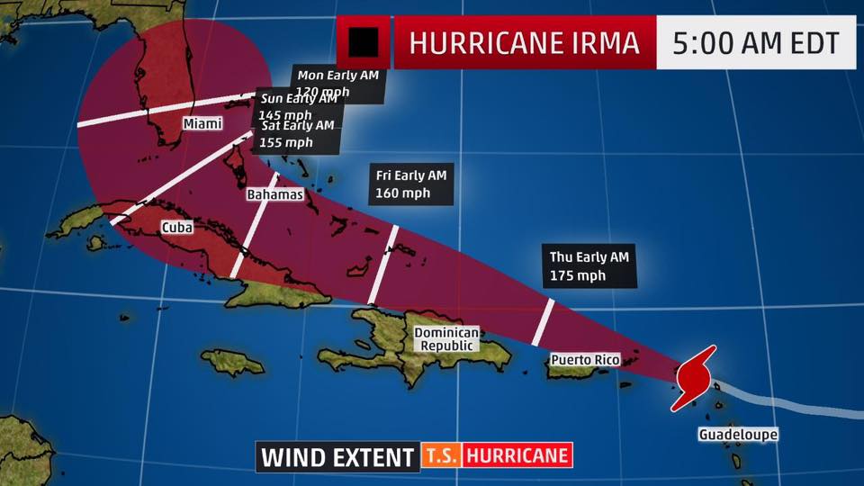
Hurricane Irma Intermediate Advisory Number 29A
NWS National Hurricane Center Miami FL AL112017
800 AM AST Wed Sep 06 2017
…EYE OF POTENTIALLY CATASTROPHIC CATEGORY 5 HURRICANE IRMA
PASSES OVER ST. MARTIN…
…NORTHERN EYEWALL POUNDING ANGUILLA…
SUMMARY OF 800 AM AST…1200 UTC…INFORMATION
———————————————-
LOCATION…18.1N 63.3W
ABOUT 15 MI…25 KM W OF ST. MARTIN
ABOUT 15 MI…25 KM WSW OF ANGUILLA
MAXIMUM SUSTAINED WINDS…185 MPH…295 KM/H
PRESENT MOVEMENT…WNW OR 285 DEGREES AT 16 MPH…26 KM/H
MINIMUM CENTRAL PRESSURE…918 MB…27.11 INCHES
WATCHES AND WARNINGS
——————–
CHANGES WITH THIS ADVISORY:
None
SUMMARY OF WATCHES AND WARNINGS IN EFFECT:
A Hurricane Warning is in effect for…
* Antigua, Barbuda, Anguilla, Montserrat, St. Kitts, and Nevis
* Saba, St. Eustatius, and Sint Maarten
* Saint Martin and Saint Barthelemy
* British Virgin Islands
* U.S. Virgin Islands
* Puerto Rico, Vieques, and Culebra
* Dominican Republic from Cabo Engano to the northern border with
Haiti
* Guadeloupe
* Southeastern Bahamas and the Turks and Caicos Islands
A Hurricane Watch is in effect for…
* Haiti from the northern border with the Dominican Republic to Le
Mole St. Nicholas
* Turks and Caicos Islands
* Southeastern Bahamas
* Cuba from Matanzas province eastward to Guantanamo province
* Central Bahamas
A Tropical Storm Warning is in effect for…
* Dominican Republic from south of Cabo Engano westward to the
southern border with Haiti
A Tropical Storm Watch is in effect for…
* Haiti from south of Le Mole St. Nicholas to Port-Au-Prince
A Hurricane Warning means that hurricane conditions are expected
somewhere within the warning area. Preparations to protect life and
property should be rushed to completion.
A Hurricane Watch means that hurricane conditions are possible
within the watch area. A watch is typically issued 48 hours
before the anticipated first occurrence of tropical-storm-force
winds, conditions that make outside preparations difficult or
dangerous.
A Tropical Storm Warning means that tropical storm conditions are
expected somewhere within the warning area.
A Tropical Storm Watch means that tropical storm conditions are
possible within the watch area, generally within 48 hours.
Interests elsewhere in the Dominican Republic and Haiti, as
well as Cuba, the northwestern Bahamas, and Florida should monitor
the progress of Irma.
For storm information specific to your area in the United
States, including possible inland watches and warnings, please
monitor products issued by your local National Weather Service
forecast office. For storm information specific to your area outside
the United States, please monitor products issued by your national
meteorological service.
DISCUSSION AND 48-HOUR OUTLOOK
——————————
At 800 AM AST (1200 UTC), the eye of Hurricane Irma was located near
latitude 18.1 North, longitude 63.3 West. Irma is moving toward the
west-northwest near 16 mph (26 km/h), and this general motion is
expected to continue for the next couple of days. On the forecast
track, the extremely dangerous core of Irma will move over portions
of the northern Virgin Islands today, pass near or just north of
Puerto Rico this afternoon or tonight, and pass near or just north
of the coast of the Dominican Republic Thursday.
Maximum sustained winds remain near 185 mph (295 km/h) with higher
gusts. Irma is a category 5 hurricane on the Saffir-Simpson
Hurricane Wind Scale. Some fluctuations in intensity are likely
during the next day or two, but Irma is forecast to remain a
powerful category 4 or 5 hurricane during the next couple of days.
Hurricane-force winds extend outward up to 50 miles (85 km) from
the center and tropical-storm-force winds extend outward up to 175
miles (280 km). A wind gust to 90 mph (146 km/h) was recently on
the island of St. Eustatius located south of the eye of Irma. A
NOAA National Ocean Service station on Barbuda reported sustained
winds of 118 mph (190 km/h) with a gust to 155 mph (249 km/h)
before the instrument failed earlier this morning.
The estimated minimum central pressure based on data from an Air
Force Reserve aircraft and earlier surface observations is 918 mb
(27.11 inches). A NOAA National Ocean Service station on Barbuda
reported a minimum pressure of 916.1 mb (27.05 inches) earlier this
morning.
HAZARDS AFFECTING LAND
———————-
STORM SURGE: The combination of a life-threatening storm surge and
large breaking waves will raise water levels ABOVE NORMAL TIDE
LEVELS by the following amounts within the hurricane warning area
near and to the north of the center of Irma. Near the coast, the
surge will be accompanied by large and destructive waves.
Northern Leeward Islands…7 to 11 ft
Turks and Caicos Islands…15 to 20 ft
Southeastern Bahamas…15 to 20 ft
Northern coast of the Dominican Republic…3 to 5 ft
Northern coast of Haiti and the Gulf of Gonave…1 to 3 ft
The combination of a life-threatening storm surge and the tide will
cause normally dry areas near the coast to be flooded by rising
waters moving inland from the shoreline. The water is expected to
reach the following HEIGHTS ABOVE GROUND if the peak surge occurs at
the time of high tide…
British and U.S. Virgin Islands except St. Croix…7 to 11 ft
Northern coast of Puerto Rico…3 to 5 ft
Southern coast of Puerto Rico and St. Croix…1 to 2 ft
The deepest water will occur along the immediate coast in areas of
onshore winds, where the surge will be accompanied by large and
destructive waves. Surge-related flooding depends on the relative
timing of the surge and the tidal cycle, and can vary greatly over
short distances. For information specific to your area, please see
products issued by your local National Weather Service forecast
office.
WIND: Hurricane conditions will continue today within the
hurricane warning area in the Leeward Islands. Hurricane
conditions are expected to begin within the British and U.S. Virgin
Islands this morning and spread westward over portions of Puerto
Rico later today. Hurricane conditions are expected to begin within
the hurricane warning area in the Dominican Republic early Thursday,
with tropical storm conditions beginning tonight. Hurricane
conditions are expected in the warning area in the southeastern
Bahamas and the Turks and Caicos Islands beginning Thursday night.
Hurricane and tropical storm conditions are possible within the
watch area in Haiti by early Thursday and in the central Bahamas
and Cuba by Friday.
RAINFALL: Irma is expected to produce the following rain
accumulations through Thursday:
Northern Leeward Islands…8 to 12 inches, isolated 20 inches
Northeast Puerto Rico and the British and U.S. Virgin Islands…4 to
10 inches, isolated 15 inches Southwest Puerto Rico, the southern
Leeward Islands, and Saint Croix…2 to 4 inches
Irma is expected to produce the following rain accumulations
Wednesday through Saturday:
Southeast Bahamas, the Turks and Caicos and eastern to central
Cuba…8 to 12 inches, isolated 20 inches
Northern Dominican Republic and northern Haiti…4 to 10 inches,
isolated 15 inches
Southwest Haiti…1 to 4 inches
In all areas this rainfall may cause life-threatening flash floods
and mudslides.
SURF: Swells generated by Irma will affect the northern Leeward
Islands, Puerto Rico, the Virgin Islands, the southeastern Bahamas,
the Turks and Caicos Islands, the northern coast of the Dominican
Republic, and portions of the southeast coast of the United States
during the next several days. These swells are likely to cause
life-threatening surf and rip current conditions. Please consult
products from your local weather office.
NEXT ADVISORY
————-
Next complete advisory at 1100 AM AST.
$$
Forecaster Brown PhotoView on Facebook·ShareLaser 101 Storm Watch Team 8 hours ago Laser 101 Storm Watch Team###500 AM UPDATE OF HURRICANE IRMA###
— Irma picks up forward movement. Center expected over St. Maarten in 2+ hours
000
WTNT31 KNHC 060853
TCPAT1
BULLETIN
Hurricane Irma Advisory Number 29
NWS National Hurricane Center Miami FL AL112017
500 AM AST Wed Sep 06 2017
…EYE OF POTENTIALLY CATASTROPHIC CATEGORY 5 HURRICANE IRMA
MOVING AWAY FROM BARBUDA AND TOWARD ST. MARTIN…
SUMMARY OF 500 AM AST…0900 UTC…INFORMATION
———————————————-
LOCATION…17.9N 62.6W
ABOUT 35 MI…55 KM ESE OF ST. MARTIN
ABOUT 145 MI…235 KM E OF ST. CROIX
MAXIMUM SUSTAINED WINDS…185 MPH…295 KM/H
PRESENT MOVEMENT…WNW OR 285 DEGREES AT 16 MPH…26 KM/H
MINIMUM CENTRAL PRESSURE…914 MB…26.99 INCHES
WATCHES AND WARNINGS
——————–
CHANGES WITH THIS ADVISORY:
The Government of the Bahamas has issued a Hurricane Warning for
the Southeastern Bahamas and the Turks and Caicos Islands, and a
Hurricane Watch for the Central Bahamas.
The Meteorological Service of Barbados has discontinued the
Tropical Storm Warning for Dominica.
SUMMARY OF WATCHES AND WARNINGS IN EFFECT:
A Hurricane Warning is in effect for…
* Antigua, Barbuda, Anguilla, Montserrat, St. Kitts, and Nevis
* Saba, St. Eustatius, and Sint Maarten
* Saint Martin and Saint Barthelemy
* British Virgin Islands
* U.S. Virgin Islands
* Puerto Rico, Vieques, and Culebra
* Dominican Republic from Cabo Engano to the northern border with
Haiti
* Guadeloupe
* Southeastern Bahamas and the Turks and Caicos Islands
A Hurricane Watch is in effect for…
* Haiti from the northern border with the Dominican Republic to Le
Mole St. Nicholas
* Turks and Caicos Islands
* Southeastern Bahamas
* Cuba from Matanzas province eastward to Guantanamo province
* Central Bahamas
A Tropical Storm Warning is in effect for…
* Dominican Republic from south of Cabo Engano westward to the
southern border with Haiti
A Tropical Storm Watch is in effect for…
* Haiti from south of Le Mole St. Nicholas to Port-Au-Prince
A Hurricane Warning means that hurricane conditions are expected
somewhere within the warning area. Preparations to protect life and
property should be rushed to completion.
A Hurricane Watch means that hurricane conditions are possible
within the watch area. A watch is typically issued 48 hours
before the anticipated first occurrence of tropical-storm-force
winds, conditions that make outside preparations difficult or
dangerous.
A Tropical Storm Warning means that tropical storm conditions are
expected somewhere within the warning area.
A Tropical Storm Watch means that tropical storm conditions are
possible within the watch area, generally within 48 hours.
Interests elsewhere in the Dominican Republic and Haiti, as
well as Cuba, the northwestern Bahamas, and Florida should monitor
the progress of Irma.
For storm information specific to your area in the United
States, including possible inland watches and warnings, please
monitor products issued by your local National Weather Service
forecast office. For storm information specific to your area outside
the United States, please monitor products issued by your national
meteorological service.
DISCUSSION AND 48-HOUR OUTLOOK
——————————
At 500 AM AST (0900 UTC), the center of Hurricane Irma was located
near latitude 17.9 North, longitude 62.6 West. Irma is moving
toward the west-northwest near 16 mph (26 km/h), and this general
motion is expected to continue for the next couple of days. On the
forecast track, the extremely dangerous core of Irma will move over
portions of the northern Leeward Islands this morning, move near or
over portions of the northern Virgin Islands later today, and pass
near or just north of Puerto Rico this afternoon or tonight.
Maximum sustained winds remain near 185 mph (295 km/h) with higher
gusts. Irma is a category 5 hurricane on the Saffir-Simpson
Hurricane Wind Scale. Some fluctuations in intensity are likely
during the next day or two, but Irma is forecast to remain a
powerful category 4 or 5 hurricane during the next couple of days.
Hurricane-force winds extend outward up to 50 miles (85 km) from the
center and tropical-storm-force winds extend outward up to 175 miles
(280 km). St. Martin recently reported a wind gust of 61 mph
(98 km/h).
The estimated minimum central pressure is 914 mb (26.99 inches).
HAZARDS AFFECTING LAND
———————-
STORM SURGE: The combination of a life-threatening storm surge and
large breaking waves will raise water levels ABOVE NORMAL TIDE
LEVELS by the following amounts within the hurricane warning area
near and to the north of the center of Irma. Near the coast, the
surge will be accompanied by large and destructive waves.
Northern Leeward Islands…7 to 11 ft
Turks and Caicos Islands…15 to 20 ft
Southeastern Bahamas…15 to 20 ft
Northern coast of the Dominican Republic…3 to 5 ft
Northern coast of Haiti and the Gulf of Gonave…1 to 3 ft
The combination of a life-threatening storm surge and the tide will
cause normally dry areas near the coast to be flooded by rising
waters moving inland from the shoreline. The water is expected to
reach the following HEIGHTS ABOVE GROUND if the peak surge occurs at
the time of high tide…
British and U.S. Virgin Islands except St. Croix…7 to 11 ft
Northern coast of Puerto Rico…3 to 5 ft
Southern coast of Puerto Rico and St. Croix…1 to 2 ft
The deepest water will occur along the immediate coast in areas of
onshore winds, where the surge will be accompanied by large and
destructive waves. Surge-related flooding depends on the relative
timing of the surge and the tidal cycle, and can vary greatly over
short distances. For information specific to your area, please see
products issued by your local National Weather Service forecast
office.
WIND: Hurricane conditions are occuring within the hurricane
warning area in the Leeward Islands and should continue through
today. Hurricane conditions are expected to begin within the
hurricane warning area in the British and U.S. Virgin Islands and
Puerto Rico later today and tonight, with tropical storm conditions
beginning this morning. Hurricane conditions are expected to begin
within the hurricane warning area in the Dominican Republic early
Thursday, with tropical storm conditions beginning tonight.
Hurricane conditions are expected in the warning area in the
southeastern Bahamas and the Turks and Caicos Islands beginning
Thursday night.
Hurricane and tropical storm conditions are possible within the
watch area in Haiti by early Thursday and in the central Bahamas by
Friday.
RAINFALL: Irma is expected to produce the following rain
accumulations through Thursday:
Northern Leeward Islands…8 to 12 inches, isolated 20 inches
Northeast Puerto Rico and the British and U.S. Virgin Islands…4 to
10 inches, isolated 15 inches Southwest Puerto Rico, the southern
Leeward Islands, and Saint Croix…2 to 4 inches
Irma is expected to produce the following rain accumulations
Wednesday through Saturday:
Southeast Bahamas, the Turks and Caicos and eastern to central
Cuba…8 to 12 inches, isolated 20 inches
Northern Dominican Republic and northern Haiti…4 to 10 inches,
isolated 15 inches
Southwest Haiti…1 to 4 inches
In all areas this rainfall may cause life-threatening flash floods
and mudslides.
SURF: Swells generated by Irma will affect the northern Leeward
Islands, Puerto Rico, the Virgin Islands, the southeastern Bahamas,
the Turks and Caicos Islands, the northern coast of the Dominican
Republic, and portions of the southeast coast of the United States
during the next several days. These swells are likely to cause
life-threatening surf and rip current conditions. Please consult
products from your local weather office.
NEXT ADVISORY
————-
Next intermediate advisory at 800 AM AST.
Next complete advisory at 1100 AM AST.
$$
Forecaster Beven PhotoView on Facebook·ShareLaser 101 Storm Watch Team 8 hours ago Laser 101 Storm Watch TeamSXM Emergency numbers:
SMMC 910 or 5431111
Police 911 or 5422222
Ambulance services 912 or 5422111
Coast guard 913
Fire Department/Disaster management 919
Fire department airport 5454222
Gebe 5443100
Animal Welfare Foundation 5208887
Taxi hotline 9221
Safe Haven 9333
Meteorological Department 5452024
Source: Eye4Weather SXM. Please double check your own emergency list as well. View on Facebook·ShareLaser 101 Storm Watch Team 10 hours ago Laser 101 Storm Watch Teamlaser101.fm/watch-live/ Watch Livelaser101.fmHave your sayCancel reply Name: * Email: * Website: Comment: Protected by WP Anti SpamThis blog is kept spam free by WP-SpamFree. View on Facebook·ShareLaser 101 Storm Watch Team 10 hours ago Laser 101 Storm Watch TeamAt 200 AM AST (0600 UTC), the eye of Hurricane Irma was located near
latitude 17.7 North, longitude 61.8 West. Irma is moving toward the
west-northwest near 15 mph (24 km/h), and this motion is expected to
continue for the next couple of days. On the forecast track, the
extremely dangerous core of Irma will move over portions of the
northern Leeward Islands tonight and early Wednesday, move near or
over portions of the northern Virgin Islands Wednesday, and pass
near or just north of Puerto Rico late Wednesday and Wednesday
night.
Maximum sustained winds remain near 185 mph (295 km/h) with higher
gusts. Irma is a category 5 hurricane on the Saffir-Simpson
Hurricane Wind Scale. Some fluctuations in intensity are likely
during the next day or two, but Irma is forecast to remain a
powerful category 4 or 5 hurricane during the next couple of days.
Hurricane-force winds extend outward up to 50 miles (85 km) from
the center and tropical-storm-force winds extend outward up to 175
miles (280 km). A National Ocean Service automated station on
Barbuda recently reported sustained winds of 119 mph (191 km/h) and
a wind gust of 155 mph (250 km/h).
The minimum central pressure estimated from Air Force and NOAA
Hurricane Hunter aircraft observations is 914 mb (26.99 inches).
The automated station on Barbuda recently reported a pressure of
927.9 mb (27.40 in). View on Facebook·ShareLaser 101 Storm Watch Team 13 hours ago Laser 101 Storm Watch TeamSUMMARY OF 1100 PM AST…0300 UTC…INFORMATION
———————————————–
LOCATION…17.4N 61.1W
ABOUT 50 MI…80 KM ENE OF ANTIGUA
ABOUT 50 MI…75 KM ESE OF BARBUDA
MAXIMUM SUSTAINED WINDS…185 MPH…295 KM/H
PRESENT MOVEMENT…WNW OR 285 DEGREES AT 15 MPH…24 KM/H
MINIMUM CENTRAL PRESSURE…916 MB…27.05 INCHES
WATCHES AND WARNINGS
——————–
CHANGES WITH THIS ADVISORY:
None.
SUMMARY OF WATCHES AND WARNINGS IN EFFECT:
A Hurricane Warning is in effect for…
* Antigua, Barbuda, Anguilla, Montserrat, St. Kitts, and Nevis
* Saba, St. Eustatius, and Sint Maarten
* Saint Martin and Saint Barthelemy
* British Virgin Islands
* U.S. Virgin Islands
* Puerto Rico, Vieques, and Culebra
* Dominican Republic from Cabo Engano to the northern border with
Haiti
* Guadeloupe
A Hurricane Watch is in effect for…
* Haiti from the northern border with the Dominican Republic to Le
Mole St. Nicholas
* Turks and Caicos Islands
* Southeastern Bahamas
* Cuba from Matanzas province eastward to Guantanamo province
A Tropical Storm Warning is in effect for…
* Dominica
* Dominican Republic from south of Cabo Engano westward to the
southern border with Haiti
A Tropical Storm Watch is in effect for…
* Haiti from south of Le Mole St. Nicholas to Port-Au-Prince
A Hurricane Warning means that hurricane conditions are expected
somewhere within the warning area. Preparations to protect life and
property should be rushed to completion.
A Hurricane Watch means that hurricane conditions are possible
within the watch area. A watch is typically issued 48 hours
before the anticipated first occurrence of tropical-storm-force
winds, conditions that make outside preparations difficult or
dangerous.
A Tropical Storm Warning means that tropical storm conditions are
expected somewhere within the warning area.
A Tropical Storm Watch means that tropical storm conditions are
possible within the watch area, generally within 48 hours.
Interests elsewhere in the Dominican Republic and Haiti, as
well as Cuba, the central and northwestern Bahamas, and Florida
should monitor the progress of Irma.
For storm information specific to your area in the United
States, including possible inland watches and warnings, please
monitor products issued by your local National Weather Service
forecast office. For storm information specific to your area outside
the United States, please monitor products issued by your national
meteorological service.
DISCUSSION AND 48-HOUR OUTLOOK
——————————
At 1100 PM AST (0300 UTC), the eye of Hurricane Irma was located
near latitude 17.4 North, longitude 61.1 West. Irma is moving
toward the west-northwest near 15 mph (24 km/h), and this motion is
expected to continue for the next couple of days. On the forecast
track, the extremely dangerous core of Irma will move over portions
of the northern Leeward Islands tonight and early Wednesday, move
near or over portions of the northern Virgin Islands Wednesday, and
pass near or just north of Puerto Rico late Wednesday and Wednesday
night.
Maximum sustained winds remain near 185 mph (295 km/h) with higher
gusts. Irma is a category 5 hurricane on the Saffir-Simpson
Hurricane Wind Scale. Some fluctuations in intensity are likely
during the next day or two, but Irma is forecast to remain a
powerful category 4 or 5 hurricane during the next couple of days.
Hurricane-force winds extend outward up to 50 miles (85 km) from the
center and tropical-storm-force winds extend outward up to 175 miles
(280 km).
The minimum central pressure estimated from Air Force and NOAA
Hurricane Hunter aircraft observations is 916 mb (27.05 inches).
HAZARDS AFFECTING LAND
———————-
STORM SURGE: The combination of a life-threatening storm surge and
large breaking waves will raise water levels ABOVE NORMAL TIDE
LEVELS by the following amounts within the hurricane warning area
near and to the north of the center of Irma. Near the coast, the
surge will be accompanied by large and destructive waves.
Northern Leeward Islands…7 to 11 ft
Turks and Caicos Islands…15 to 20 ft
Southeastern Bahamas…15 to 20 ft
Northern coast of the Dominican Republic…3 to 5 ft
Northern coast of Haiti and the Gulf of Gonave…1 to 3 ft
The combination of a life-threatening storm surge and the tide will
cause normally dry areas near the coast to be flooded by rising
waters moving inland from the shoreline. The water is expected to
reach the following HEIGHTS ABOVE GROUND if the peak surge occurs at
the time of high tide…
British and U.S. Virgin Islands except St. Croix…7 to 11 ft
Northern coast of Puerto Rico…3 to 5 ft
Southern coast of Puerto Rico and St. Croix…1 to 2 ft
The deepest water will occur along the immediate coast in areas of
onshore winds, where the surge will be accompanied by large and
destructive waves. Surge-related flooding depends on the relative
timing of the surge and the tidal cycle, and can vary greatly over
short distances. For information specific to your area, please see
products issued by your local National Weather Service forecast
office.
WIND: Hurricane conditions are expected within the hurricane
warning area in the Leeward Islands tonight, with tropical storm
conditions beginning within a couple of hours. Hurricane
conditions are expected to begin within the hurricane warning area
in the British and U.S. Virgin Islands and Puerto Rico on Wednesday,
with tropical storm conditions beginning tonight. Hurricane
conditions are expected to begin within the hurricane warning area
in the Dominican Republic early Thursday, with tropical storm
conditions beginning Wednesday night.
Hurricane and tropical storm conditions are possible within the
watch area in Haiti, the Turks and Caicos Islands, and the
southeastern Bahamas by early Thursday.
RAINFALL: Irma is expected to produce the following rain
accumulations through Thursday:
Northern Leeward Islands…8 to 12 inches, isolated 20 inches
Northeast Puerto Rico and the British and U.S. Virgin Islands
except St. Croix…4 to 10 inches, isolated 15 inches
Southwest Puerto Rico, the southern Leeward Islands, and
St. Croix…2 to 4 inches
Irma is expected to produce the following rain accumulations
Wednesday through Saturday:
Southeast Bahamas and Turks and Caicos…8 to 12 inches, isolated 20
inches
Northern Dominican Republic and northern Haiti…4 to 10 inches,
isolated 15 inches
Southwest Haiti…1 to 4 inches
These rains could cause life-threatening flash floods and mudslides.
SURF: Swells generated by Irma will affect the northern Leeward
Islands, Puerto Rico, the Virgin Islands, the southeastern Bahamas,
the Turks and Caicos Islands, and the northern coast of the
Dominican Republic during the next several days. These swells are
likely to cause life-threatening surf and rip current conditions.
Please consult products from your local weather office.
NEXT ADVISORY
————-
Next intermediate advisory at 200 AM AST.
Next complete advisory at 500 AM AST. View on Facebook·ShareLaser 101 Storm Watch Team 15 hours ago Laser 101 Storm Watch TeamLaser 101 Storm Watch Team shared NV GEBE’s post. NV GEBEGood day to the general public,
Thank you for your reports, queries and concerns regarding the water situation today September 5, 2017.
Seven Seas Water, the water production company has discontinued the production of water due to the ground seas.
During the passing of a hurricane, tanks should be filled to capacity to:
1. Ensure at least a 2 day storage of water to the community.
2. To prevent the tanks being damaged.
Yesterday NV GEBE ensured all tanks were filled to capacity, however, by this morning water technicians realised that the tanks were running low. NV GEBE was therefore compelled to discontinue the water supply.
This was an emergency decision to ensure water was sufficient for the community after the storm.
NV GEBE apologises for the inconvenience this has caused.
* *Update on electricity* *
NV GEBE hereby informs the general public that electricity will remain on as long as possible, however once the situation deteriorates and it becomes unsafe, electricity will be shut off until it is safe to restore the power.
We encourage the general public to exercise extreme caution, stay away from fallen lines, as wires may be live without your knowledge. Do not attempt to move lines even if they are insulated. Please call our emergency numbers at 1 844 432 3213 or 1 721 544 3100/ 546 11 89/ 546 11 60/ 546 1100 / 546 2283 or 546 11 93.
#NVGEBE View on Facebook·ShareLaser 101 Storm Watch Team 17 hours ago Laser 101 Storm Watch TeamSUMMARY OF 800 PM AST…0000 UTC…INFORMATION
———————————————-
LOCATION…17.2N 60.5W
ABOUT 85 MI…140 KM E OF ANTIGUA
ABOUT 90 MI…145 KM ESE OF BARBUDA
MAXIMUM SUSTAINED WINDS…185 MPH…295 KM/H
PRESENT MOVEMENT…W OR 280 DEGREES AT 15 MPH…24 KM/H
MINIMUM CENTRAL PRESSURE…916 MB…27.05 INCHES
WATCHES AND WARNINGS
——————–
CHANGES WITH THIS ADVISORY:
The Meteorological Service of Cuba has issued a Hurricane Watch for
Cuba from the provinces of Matanzas eastward to Guantanamo.
SUMMARY OF WATCHES AND WARNINGS IN EFFECT:
A Hurricane Warning is in effect for…
* Antigua, Barbuda, Anguilla, Montserrat, St. Kitts, and Nevis
* Saba, St. Eustatius, and Sint Maarten
* Saint Martin and Saint Barthelemy
* British Virgin Islands
* U.S. Virgin Islands
* Puerto Rico, Vieques, and Culebra
* Dominican Republic from Cabo Engano to the northern border with
Haiti
A Hurricane Watch is in effect for…
* Guadeloupe
* Haiti from the northern border with the Dominican Republic to Le
Mole St. Nicholas
* Turks and Caicos Islands
* Southeastern Bahamas
* Cuba from Matanzas province eastward to Guantanamo province
A Tropical Storm Warning is in effect for…
* Guadeloupe
* Dominica
* Dominican Republic from south of Cabo Engano westward to the
southern border with Haiti
A Tropical Storm Watch is in effect for…
* Haiti from south of Le Mole St. Nicholas to Port-Au-Prince
A Hurricane Warning means that hurricane conditions are expected
somewhere within the warning area. Preparations to protect life and
property should be rushed to completion.
A Hurricane Watch means that hurricane conditions are possible
within the watch area. A watch is typically issued 48 hours
before the anticipated first occurrence of tropical-storm-force
winds, conditions that make outside preparations difficult or
dangerous.
A Tropical Storm Warning means that tropical storm conditions are
expected somewhere within the warning area.
A Tropical Storm Watch means that tropical storm conditions are
possible within the watch area, generally within 48 hours.
Interests elsewhere in the Dominican Republic and Haiti, as
well as Cuba, the central and northwestern Bahamas, and Florida
should monitor the progress of Irma.
For storm information specific to your area in the United
States, including possible inland watches and warnings, please
monitor products issued by your local National Weather Service
forecast office. For storm information specific to your area outside
the United States, please monitor products issued by your national
meteorological service.
DISCUSSION AND 48-HOUR OUTLOOK
——————————
At 800 PM AST (0000 UTC), the distinct eye of Hurricane Irma was
located near latitude 17.2 North, longitude 60.5 West. Irma is
moving toward the west near 15 mph (24 km/h). A turn toward the
west-northwest is forecast to begin tonight and continue for the
next couple of days. On the forecast track, the extremely dangerous
core of Irma will move over portions of the northern Leeward Islands
tonight and early Wednesday, move near or over portions of the
northern Virgin Islands Wednesday, and pass near or just north of
Puerto Rico late Wednesday and Wednesday night.
Maximum sustained winds are near 185 mph (295 km/h) with higher
gusts. Irma is an extremely dangerous category 5 hurricane on the
Saffir-Simpson Hurricane Wind Scale. Some fluctuations in intensity
are likely during the next day or two, but Irma is forecast to
remain a powerful category 4 or 5 hurricane during the next couple
of days.
Hurricane-force winds extend outward up to 60 miles (95 km) from
the center and tropical-storm-force winds extend outward up to 175
miles (280 km).
The minimum central pressure estimated from Hurricane Hunter
observations is 916 mb (27.05 inches).
HAZARDS AFFECTING LAND
———————-
STORM SURGE: The combination of a life-threatening storm surge and
large breaking waves will raise water levels ABOVE NORMAL TIDE
LEVELS by the following amounts within the hurricane warning area
near and to the north of the center of Irma. Near the coast, the
surge will be accompanied by large and destructive waves.
Northern Leeward Islands…7 to 11 ft
Turks and Caicos Islands…15 to 20 ft
Southeastern Bahamas…15 to 20 ft
Northern coast of the Dominican Republic…3 to 5 ft
Northern coast of Haiti and the Gulf of Gonave…1 to 3 ft
The combination of a life-threatening storm surge and the tide will
cause normally dry areas near the coast to be flooded by rising
waters moving inland from the shoreline. The water is expected to
reach the following HEIGHTS ABOVE GROUND if the peak surge occurs at
the time of high tide…
British and U.S. Virgin Islands except St. Croix…7 to 11 ft
Northern coast of Puerto Rico…3 to 5 ft
Southern coast of Puerto Rico and St. Croix…1 to 2 ft
The deepest water will occur along the immediate coast in areas of
onshore winds, where the surge will be accompanied by large and
destructive waves. Surge-related flooding depends on the relative
timing of the surge and the tidal cycle, and can vary greatly over
short distances. For information specific to your area, please see
products issued by your local National Weather Service forecast
office.
WIND: Hurricane conditions are expected within the hurricane
warning area in the Leeward Islands tonight, with tropical storm
conditions beginning within the next few hours. Hurricane
conditions are expected to begin within the hurricane warning area
in the British and U.S. Virgin Islands and Puerto Rico on Wednesday,
with tropical storm conditions beginning tonight. Hurricane
conditions are expected to begin within the hurricane warning area
in the Dominican Republic early Thursday, with tropical storm
conditions beginning Wednesday night.
Hurricane and tropical storm conditions are possible within the
watch area in Haiti, the Turks and Caicos Islands, and the
southeastern Bahamas by early Thursday.
RAINFALL: Irma is expected to produce the following rain
accumulations through Thursday:
Northern Leeward Islands…8 to 12 inches, isolated 20 inches
Northeast Puerto Rico and the British and U.S. Virgin Islands
except St. Croix…4 to 10 inches, isolated 15 inches
Southwest Puerto Rico, the southern Leeward Islands, and
St. Croix…2 to 4 inches
Irma is expected to produce the following rain accumulations
Wednesday through Saturday:
Southeast Bahamas and Turks and Caicos…8 to 12 inches, isolated 20
inches
Northern Dominican Republic and northern Haiti…4 to 10 inches,
isolated 15 inches
Southwest Haiti…1 to 4 inches
These rains could cause life-threatening flash floods and mudslides.
SURF: Swells generated by Irma will affect the northern Leeward
Islands, Puerto Rico, the Virgin Islands, the southeastern Bahamas,
the Turks and Caicos Islands, and the northern coast of the
Dominican Republic during the next several days. These swells are
likely to cause life-threatening surf and rip current conditions.
Please consult products from your local weather office.
NEXT ADVISORY
————-
Next complete advisory at 1100 PM AST. PhotoView on Facebook·ShareLaser 101 Storm Watch Team 19 hours ago Laser 101 Storm Watch TeamThe shelters that will open as of 4 pm are as follows:
New Testament Baptist Church in Philipsburg
Sister Marie-Laurence Primary School in Middle Region
Belvedere Community Center in Belvedere
Dutch Quarter Community Center in Dutch Quarter
Rupert I Maynard Youth Community Center St. Peters
NIPA National Institute for Professional Advancement Cay Hill
Christian Fellowship Church Across from Pineapple Pete’s Cole Bay
A curfew will go into effect as from 6:00 PM today. It is mandatory to stay indoors until it has been lifted. Photo